
INTRODUCTION
Epidemiology examines the distribution and determinants of health-related conditions across populations and applies this knowledge to their prevention and control (Savitz et al., 1999). Building on this foundation, Akers and Lanier (2009) introduced epidemiological criminology as an integrative framework that draws on the theories, methods, and measures of epidemiology and criminology to examine relationships among public health, crime, and criminal justice. General strain theory conceptualizes poor health as an adverse condition that may generate negative emotions and increase the likelihood of criminal or other maladaptive coping responses (Agnew, 1992, 2001; Kort-Butler, 2017; Schroeder et al., 2011; Stogner & Gibson, 2010). Agnew’s (1999) extension of the theory to the community level further establishes its relevance to the study of place, suggesting that communities vary in both their exposure to strain and the extent to which strain contributes to crime. Accordingly, aggregate measures of poor mental and physical health may represent not only the clinical conditions of individual residents but also an area’s broader health burden, population vulnerability, and community-level strain, all of which may contribute to higher levels of crime (Weisburd et al., 2026).
However, community health alone cannot explain why crime clusters at particular places. Routine activities theory and environmental criminology direct attention to the physical setting and how that setting brings together motivated offenders, suitable targets, and the absence of capable guardians (Brantingham & Brantingham, 1995; Cohen & Felson, 1979). Land use is a central feature of the environment because it structures where, when, and under what conditions people and activities converge. Different land uses therefore produce varying levels of guardianship and place management, creating distinct opportunity structures for crime (Eck, 2018; Kinney et al., 2008). Some land uses generate greater opportunities for crime because of weak guardianship, ineffective place management, or the concentration of potential offenders and targets. For example, assaults often cluster around bars (Eck, 1994), whereas theft and vandalism may concentrate near shopping centers and high schools (McCord & Ratcliffe, 2009).
Community health and crime are not merely variables that happen to cluster in the same places. Their spatial distributions may reflect deeper inequalities in access to health-promoting resources, safe environments, economic opportunities, and institutional protection. Viewed through the lens of spatial justice, examining where poor health and crime concentrate raises a broader question: whether the conditions necessary for health and personal security are distributed equitably across communities. Although the present analysis focuses on a single city and does not claim to represent urban life more generally, the parcels and tracts where disadvantage accumulates may also be places where the resources that support health and safety are less available. It is this spatial convergence—rather than any inherent characteristic of the people who live in these areas—that this study ultimately seeks to examine. This convergence places the study within a larger debate: should crime be understood primarily through individual behavior and policing, or also through broader inequalities in health, place, resources, and opportunity? Treating crime mainly as individual misconduct to be managed through enforcement leaves unexamined how community health, economic vulnerability, and environmental conditions may shape where crime becomes concentrated.
The research gap this study addresses is twofold. Empirically, community health and land use have been examined largely as separate explanations of where crime occurs, and few studies have modeled area-level mental and physical health alongside parcel-level land use within a single framework (Weisburd et al., 2026). It thus remains unclear whether community health is associated with crime concentration beyond the opportunity structure created by land use, and whether any such association persists after accounting for unobserved differences across census tracts. Conceptually, the co-location of poor health and crime has rarely been examined as a matter of structural inequality and spatial justice rather than individual pathology. The remainder of the paper is organized as follows. I first review research linking community health, strain, and crime, followed by research on land use, opportunity, and crime. I then bring these bodies of literature together to develop the study hypotheses. The subsequent sections describe the data and methods, present the results, and discuss what the findings do—and do not—demonstrate.
LITERATURE REVIEW
Epidemiological criminology examines crime in relation to the broader determinants of health (Akers & Lanier, 2009). Within this framework, health problems that are severe, persistent, or inadequately managed may constitute strains that generate negative emotions and maladaptive coping (Agnew, 1992, 2001), while opportunity perspectives emphasize how health behaviors and everyday activities shape exposure to criminogenic settings and guardianship. Prior research has accordingly examined sleep, leisure, healthcare access, mental health, and physical health.
Specifically, studies of sleep generally find that insufficient or poor-quality sleep is associated with offending through both physical- and mental-health pathways. Clinkinbeard et al. (2011), for example, reported that sleeping fewer than seven hours per night was associated with greater property delinquency and fewer than six hours with greater violent delinquency. Raine and Venables (2017) found that adolescent sleepiness predicted offending in adulthood. Findings on leisure are more mixed. Unstructured leisure characterized by boredom and idleness (Mirić, 2016) and peer-oriented leisure (Agnew & Petersen, 1989) have been associated with greater delinquency, whereas organized leisure (Agnew & Petersen, 1989) and physical activity among detained youth (Behjati Ardakani & Ghanbarpoor Nosrati, 2015) have been associated with less delinquency. These patterns fit both routine activities theory (Cohen & Felson, 1979) and strain theory, as physical activity may offer a prosocial way of coping with strain.
Healthcare access and insurance coverage may likewise be associated with offending. In Türkiye, expansion of Green Card health insurance was associated with lower rates of assault, theft, and property damage (Acar & Tirgil, 2025). Studies of Medicaid expansion in the United States reach broadly similar conclusions. Aslim et al. (2022) found no significant overall effect on one-year recidivism but identified a significant reduction among individuals with multiple prior violent offenses. He and Barkowski (2020) and Vogler (2020) likewise found Medicaid expansion associated with reductions in violent crime, especially among young adults.
Mental health, particularly depression, has received substantial attention. Ozkan et al. (2019) found inconsistent cross-sectional associations but longitudinal links to aggressive and income-generating offenses, and Link et al. (2019) found depression associated with family conflict and, in turn, reincarceration. Fazel et al. (2015) found higher rates of violent crime among individuals with depression after accounting for confounders, and Tayebi et al. (2024, 2026) linked depression to nonviolent offending across neighborhood types and to greater odds of conviction across offense types. From a general strain theory perspective, mental health problems may operate as strains (Agnew, 1992), but this literature does not imply that people experiencing mental illness are generally prone to crime. The absolute risk of violent offending among people with depression remains low (Fazel et al., 2015), and people with mental illness are disproportionately vulnerable to victimization (Teplin et al., 2005) and to stigma and discrimination (B. G. Link & Phelan, 2001).
Evidence on physical health is more mixed. Some research characterizes the association as weak (Farrington, 1995), whereas Schroeder et al. (2011) found better health associated with lower offending, although deteriorating health did not predict subsequent increases. Chronic illness, pain, and disability have been linked to delinquency after accounting for traditional strains (Stogner & Gibson, 2010), to elevated drug use among chronically ill adolescent females (Suris & Parera, 2005), and to fighting and other risky behaviors among students with disabilities or long-term health problems (Jones & Lollar, 2008). The relationship may also be reciprocal (Stogner et al., 2014) and may operate through accumulated stress, impeded employment, and depressive symptoms (Kort-Butler, 2017; N. W. Link et al., 2019).
Beyond health-related conditions, environmental contexts differ in the opportunities they create for crime. Routine activities theory holds that crime occurs when a motivated offender, a suitable target, and the absence of capable guardianship converge in time and space (Cohen & Felson, 1979), and land use shapes these conditions by influencing where people and targets concentrate and how strongly places are guarded and managed (Lee et al., 2022). Crime around Philadelphia subway stations clustered at a small number of stations (McCord & Ratcliffe, 2009), commercial land uses both generated and attracted crime (Kinney et al., 2008), and the highest-crime Los Angeles bus stops experienced rates 20 to 30 times the average, often amid heavy pedestrian traffic, bars and liquor stores, vacant buildings, and limited surveillance (Loukaitou-Sideris, 1999). The present study examines whether such patterns hold at the parcel level after accounting for the health conditions of the surrounding community.
The community health and land use literatures have developed largely in parallel: research on health and crime rarely accounts for the physical settings in which crime occurs, and research on land use rarely considers the health context of surrounding populations (Weisburd et al., 2026). Yet the two are complementary. Community health captures broader contextual conditions—health burdens, population vulnerability, and community strain—whereas land use captures the immediate opportunity structures in which offenders, targets, and guardianship converge. Examining them together makes it possible to ask whether community health is associated with crime beyond the opportunity structure of individual parcels, and whether such associations may reflect broader inequalities in the resources that promote health and safety.
This study examines whether community mental and physical health conditions are associated with crime at individual parcels and whether those relationships remain after accounting for land use and differences across census tracts. The following hypotheses guide the analysis:
H1. Poorer community health conditions are positively associated with the number of crimes at a parcel.
H2. Parcel-level land use will account for additional variation in crime by capturing differences in criminal opportunity, while selected community health measures will remain associated with parcel-level crime after land use and differences across census tracts are considered.
METHODS
The study area is the City of Sarasota, Florida. The analytic dataset includes 28,193 tax parcels nested within 25 census tracts. Land use and crime are measured at the parcel level and community health at the tract level, so the analysis examines whether the health context of a tract is associated with variation in crime across the parcels within it.
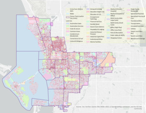
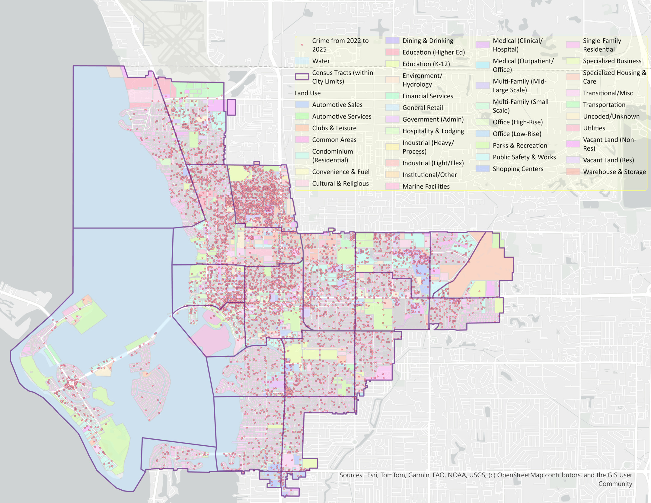
Data come from four sources. The Sarasota Police Department (SPD) provided incident-based records with geographic coordinates for crimes recorded from 2022 through 2025, which I geocoded to the parcels on which they occurred with a hit rate above 98 percent, exceeding the minimum recommended by Ratcliffe (2004). The Sarasota County Property Appraiser provided parcel land use classifications in 38 categories as of 2025. The CDC PLACES program provided tract-level health estimates based on data collected from 2022 through 2025, along with tract population and the percentage of residents aged 18 or older, and the U.S. Census Bureau provided measures of racial composition and poverty. Figure 1 maps parcels by land use alongside geocoded incidents, which cluster in the downtown core and along central and northern commercial corridors.
The dependent variable is the number of police-recorded crime incidents at each parcel, drawn from incident-based records provided directly by the SPD. These records indicate where incidents were reported or recorded, not who was responsible or where offenders live. Recorded counts therefore reflect reporting and enforcement practices as well as the occurrence of harmful behavior, and higher counts in an area do not indicate higher offending by its residents. Crime incidents were not disaggregated into violent, property, and other offense categories to preserve statistical power, particularly given the limited number of census tracts where the parcels are nested.
The focal predictors are nine CDC PLACES measures, each a tract-level crude prevalence percentage: depression, no leisure-time physical activity, frequent physical distress, frequent mental distress, fair or poor general health, short sleep duration, binge drinking, lack of health insurance, and receipt of a routine checkup in the past year. Frequent physical and mental distress denote reporting poor physical or mental health on 14 or more of the preceding 30 days; fair or poor general health is a self-rating of overall physical, mental, and social health; and depression reflects a clinical diagnosis rather than reported symptoms. Because these are tract-level estimates, they characterize the health context of the community rather than any individual resident, and all parcels within a tract share the same values.
Land use is measured with 38 parcel-level binary indicators. Single-family residential parcels serve as the reference category because they are prevalent throughout the study area and provide a meaningful low-activity baseline (Lee et al., 2022).
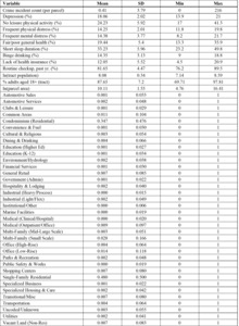
The models include five controls: the natural logarithm of tract population, the percentage of tract residents aged 18 or older, the percentage of the tract population identified as White, the percentage of households below the federal poverty threshold, and the natural logarithm of parcel area. Racial composition and poverty are included as markers of residential segregation and concentrated disadvantage, which are associated with both community health and recorded crime; their inclusion adjusts the health estimates for these structural conditions and is not intended to estimate an effect of race. Table 1 presents descriptive statistics.
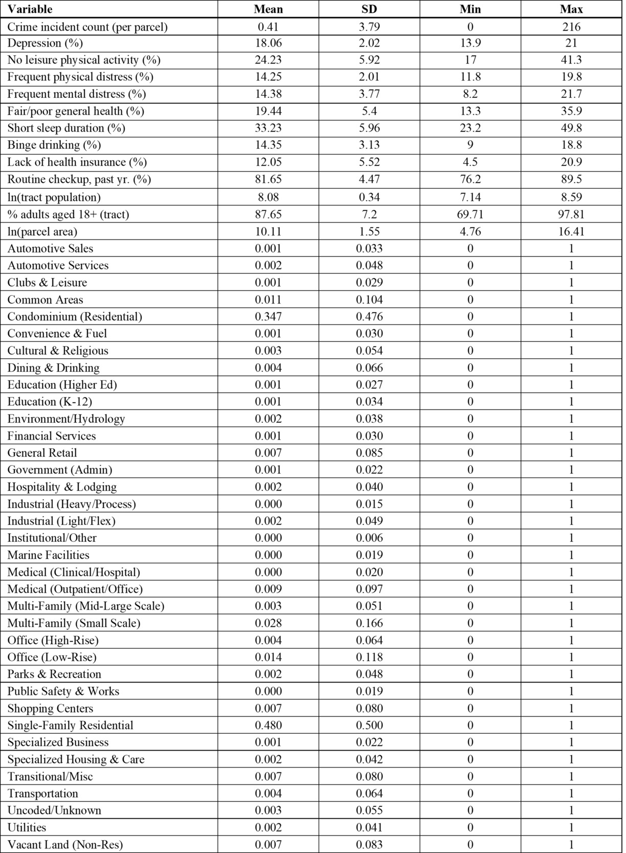
Because the dependent variable is a nonnegative count, I use Poisson regression, which yields consistent estimates of the conditional mean under overdispersion when the mean is correctly specified and robust standard errors are used (Cameron & Trivedi, 2013; Wooldridge, 2010). This approach is consistent with prior land use and crime research modeling parcel-level crime counts (Lee et al., 2022).
The analysis proceeds in two stages. Model 1 regresses parcel incident counts on the health measures and controls, with standard errors clustered by census tract. Model 2 adds land use and estimates a mixed-effects Poisson model with a tract-level random intercept and robust standard errors, accounting for both observed land use differences and unobserved heterogeneity across tracts. Comparing the two models indicates whether health associations persist once these sources of variation are considered.
Although the nine health measures are strongly intercorrelated—17 of the 36 unique pairwise correlations exceed .80 in absolute value—I retain all nine, for two reasons. First, each is a distinct CDC PLACES construct: depression reflects a diagnosed condition, frequent mental distress a count of poor mental-health days, and fair or poor general health a global self-assessment, so combining them would obscure conceptually important distinctions. Second, multicollinearity does not bias coefficients: under a correctly specified conditional mean, Poisson quasi-maximum-likelihood estimates remain consistent, whereas dropping correlated but theoretically relevant covariates could introduce omitted-variable bias (Cameron & Trivedi, 2013; Wooldridge, 2010). Collinearity does, however, make individual coefficients imprecise and potentially unstable, so statistical significance alone does not establish that an association is robust, and individual magnitudes and signs among the most highly correlated measures are not interpreted substantively. Inference is further limited because the health measures vary across only 25 tracts: the 28,193 parcels do not provide independent observations of community health, and cluster-robust standard errors can be unreliable with so few clusters. Tract-level associations are therefore treated as exploratory, with emphasis on patterns that remain consistent across both models. All analyses were conducted in Stata 19.
RESULTS
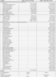
Table 2 presents both models. In Model 1, depression (1.121) and fair or poor general health (1.563) were significantly positively associated with parcel-level crime, whereas frequent physical distress (−2.157) and frequent mental distress (−1.918) were significantly negatively associated with crime. No leisure-time physical activity, short sleep duration, binge drinking, lack of health insurance, and routine checkup were not statistically significant. Among the controls, poverty and parcel area were significantly positively associated with crime. Model 1 had a pseudo-R2 of .089.
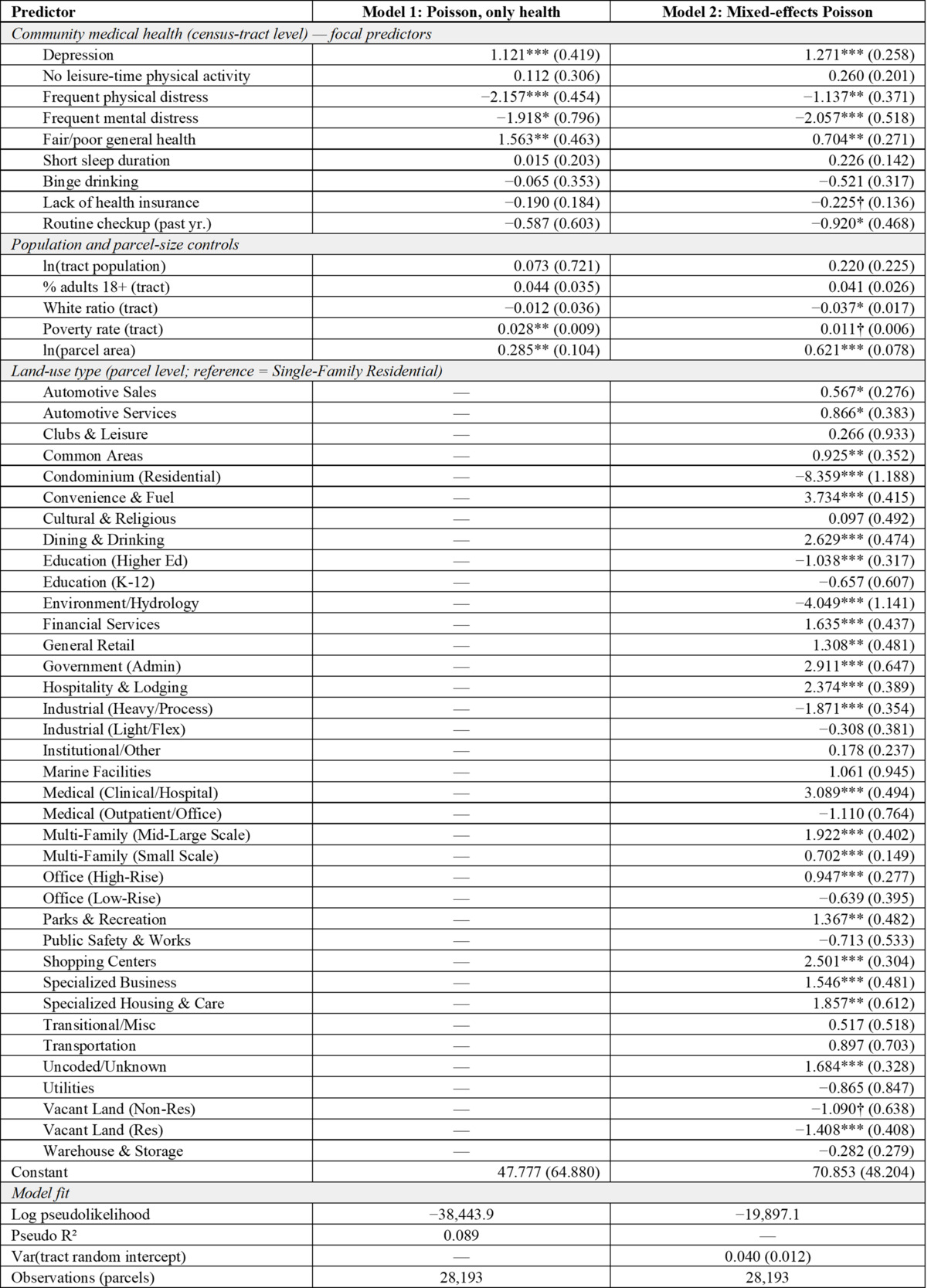
Model 2 accounts for parcel-level land use and unobserved differences across census tracts. Depression (1.271) and fair or poor general health (0.704) remained significantly positively associated with parcel-level crime. Frequent physical distress (−1.137), frequent mental distress (−2.057), and receipt of a routine checkup (−0.920) showed significant negative associations with crime. Lack of health insurance was also negatively associated with crime but was marginally significant (−0.225, p < .10). No leisure-time physical activity (0.260), short sleep duration (0.226), and binge drinking (−0.521) were not statistically significant.
Land use was strongly associated with crime. Relative to single-family residential parcels, crime counts were significantly higher at convenience and fuel parcels (3.734), medical and hospital parcels (3.089), government and administrative parcels (2.911), dining and drinking establishments (2.629), shopping centers (2.501), hospitality and lodging parcels (2.374), medium- to large-scale multifamily parcels (1.922), and specialized housing and care facilities (1.857), as well as at several other commercial, recreational, and residential uses (Table 2).
In contrast, condominium residential parcels (−8.359), environmental and hydrological parcels (−4.049), heavy industrial parcels (−1.871), vacant residential land (−1.408), and higher-education parcels (−1.038) had significantly lower crime counts than single-family residential parcels. Parcel area remained positively and significantly associated with crime (0.621). The percentage of White residents was negatively and significantly associated with recorded crime (−0.037), an association interpreted in the Discussion as a marker of structural conditions rather than a characteristic of residents, while poverty was positively but marginally significant (0.011, p < .10). The tract-level random-intercept variance was .040, indicating that some variation in baseline crime remained across tracts.
DISCUSSION
This study examined whether community health conditions are associated with parcel-level crime after accounting for land use and tract-level differences. The findings partially support H1 and support H2: depression and fair or poor general health were positively associated with crime in both models, whereas frequent physical and mental distress were negatively associated with crime, and land use was strongly associated with crime.
The positive associations for depression and fair or poor general health require careful interpretation. These measures reflect tract-level prevalence rather than individual diagnoses, and the study does not establish that people experiencing depression or other mental illness are more likely to commit crimes in Sarasota; the incidents analyzed cannot be linked to the health of residents or of those involved. They may instead capture contextual conditions such as structural disadvantage, unmet healthcare needs, economic insecurity, and cumulative vulnerability. People experiencing mental illness are, moreover, disproportionately vulnerable to victimization and to unequal treatment (B. G. Link & Phelan, 2001; Teplin et al., 2005).
The land use findings support routine activities theory. Relative to single-family residential parcels, crime was higher at high-activity commercial, institutional, medical, lodging, and multifamily uses, which concentrate offenders and targets while complicating guardianship and place management, and lower at less active or restricted uses. Elevated counts at medical and specialized housing and care facilities warrant particular care: these sites may generate reports through institutional reporting practices, large service populations, and high visitor volume, and incidents there may involve patients, staff, or visitors as victims. Because the outcome aggregates all offense types and does not identify who was responsible, these results do not indicate that patients or residents are responsible for elevated crime. Community health and land use thus provide complementary information: the former reflects broader strain and vulnerability, the latter the settings where offenders, targets, and limited guardianship converge.
Because the health measures are strongly intercorrelated and vary across only 25 tracts, individual coefficients should not be interpreted in isolation. Depression and fair or poor general health remain positive and significant in both models, and frequent physical and mental distress retain their negative signs, so these associations are not specific to one way of modeling tract-level dependence. Both models, however, include the same nine measures, and strong collinearity can make individual coefficients unstable and sensitive to specification; statistical significance therefore does not establish that any single association is robust. In sensitivity analyses that replaced the nine measures with composite indices or retained only depression and fair or poor general health, these associations were not statistically significant. The negative coefficients should likewise not be read as protective effects, as they may reflect how shared variance is partitioned among closely related measures.
The most plausible interpretation is therefore that community health measures collectively provide information about the micro-spatial distribution of recorded crime, with depression and fair or poor general health showing the most consistent positive associations in the two main models. The findings remain contextual rather than individual-level or causal because the health measures are observed at the tract level and the analysis does not identify offender motivation or the individuals involved in particular incidents. The negative association between the proportion of White residents and recorded crime requires similar caution. Racial composition was included as a control for structural conditions rather than to estimate an effect of race, and its coefficient cannot support conclusions about the criminal propensity of any racial group. Several unmeasured processes could produce this association: residential segregation and historical disinvestment may shape where incidents occur and are recorded, and policing intensity and reporting practices may differ across neighborhoods. Because the study does not measure these processes directly, they are possible explanations rather than established findings.
These findings speak to the broader debate over how crime should be understood. Explanations focused on individual behavior and policing tend to locate the causes of crime in offenders and the solutions in enforcement. The results are consistent with a broader structural perspective. Recorded crime was concentrated both in places where land use created opportunities and in census tracts with greater burdens of poor health, and poverty was positively associated with recorded crime in the health-only model. These are associations with where incidents were recorded, not with offending by residents, and the analysis does not directly measure healthcare access, institutional protection, or policing practices. Together, these patterns suggest that community health, economic vulnerability, and environmental conditions are associated with the geography of crime. Individual behavior and policing remain relevant, but the patterns suggest that inequalities in health, resources, and opportunity merit attention in explaining where crime concentrates.
Viewed through a human-rights and spatial-justice lens, the concentration of poor health and crime should not be interpreted primarily as evidence of problematic individuals or communities, but as a potential indicator of unequal exposure to conditions affecting health, safety, opportunity, and well-being. This is the study’s strongest connection to global justice: the central question is not simply who offends, but whether health, safety, resources, and institutional protection are distributed equitably across communities, a question these data can raise but cannot resolve.
Although situated in Sarasota, the study raises broader questions of global justice. Cities worldwide contain substantial inequalities in access to healthcare, safe public environments, housing, transportation, economic resources, and institutional protection, suggesting the value of comparative research on whether these relationships hold across cities with different welfare systems, healthcare regimes, levels of inequality, policing structures, and urban forms.
For prevention, studies of health and crime should account for land use to distinguish community conditions from parcel-level opportunity. Place-based prevention need not rely primarily on surveillance or policing: the land use findings support attention to guardianship, environmental design, and place management, and a health- and justice-oriented approach also directs attention to healthcare access, community services, safe public infrastructure, and housing conditions, although this analysis does not establish that such interventions would reduce crime.
Several limitations qualify these conclusions. The cross-sectional design cannot establish temporal order or causality. The health measures characterize only 25 tracts rather than individuals, limiting contextual variation and the reliability of tract-level associations. The outcome combines all recorded incident types, and associations with community health, as well as the elevated counts at medical and care facilities, may differ substantially across violent, property, and other offenses. Finally, land use categories identify parcel function but do not directly measure pedestrian activity, operating hours, guardianship, target availability, or place-management practices.
CONCLUSIONS
Despite these limitations, the study suggests that understanding crime concentration requires attention to both place and community context. Land use captures opportunities at individual parcels, while community health identifies broader conditions associated with where crime occurs. A parcel is not simply a type of land use; it is a type of land use situated within a community, and both levels are associated with the spatial distribution of recorded crime. Understanding where crime concentrates may therefore require looking beyond individual behavior and policing, although the mechanisms linking health, resources, and recorded crime remain to be tested directly.